Rexhame Beach: A Local Visitor Guide
Rexhame Beach is Marshfield's town beach, at the end of Standish Street in the Rexhame village on the town's northern shore. It is really two beaches sharing one narrow strip of sand: the open Atlantic on one side, and the South River and its salt marsh on the other. That double identity is what makes it worth planning around. The same visit can hold an ocean swim, a walk across tidal flats, a paddle on the river, and a sunset over the marsh — without moving the car.
Where the river used to meet the sea
Rexhame is Marshfield’s beach-first village: cottage streets at the end of Standish Street that exist because of the beach at their feet. Where the other villages grew up around a harbor, a fairground, or a general store, Rexhame grew around sand — summer houses behind the dunes, the ocean in front, and the South River sliding past behind.
The geography used to be different. The South River once reached the Atlantic here, at Rexhame — the old mouth is marked in the beach lot. In 1898 the Portland Gale tore a new mouth through the barrier beach to the north, up by Humarock, and the river has run out there ever since. What the old mouth left behind is the making of modern Rexhame: a wide, quiet river side — marsh, tidal flats, and sunsets — folded in behind an ocean beach.
Before any of it was a summer colony, this shore was a farm. Its ownership traces back to the Beadle and Kent families, and the name it kept is the Ames family’s — the Ames farm, whose cattle grazed the beach itself and the salt meadows around it. Rexhame’s cottages grew out of that working farmland, which is why the village still reads as a shore that was used long before it was visited.
Into the twentieth century this was the Sea Rivers Club’s shore, until 1950, when the club sold the town more than five acres of marsh and beachfront for $15,000. Rexhame has been Marshfield’s town beach ever since — the village’s front yard, kept public. The practical chapters below are how it works today.
The town has owned the beach since 1950, when the Sea Rivers Club sold the town more than five acres of marsh and beachfront for $15,000. It has been Marshfield's public beach ever since, and it works like one: lifeguards, restrooms, and a snack bar in season, a big lot, and day passes for visitors who don't hold a resident sticker. What follows is the practical version — how access and parking actually work, how the tides change the beach hour by hour, and how to time a day here. For the whole coast in one place, explore our complete Marshfield Local's Guide — every beach, restaurant, and village on this shoreline.
Getting there and public access
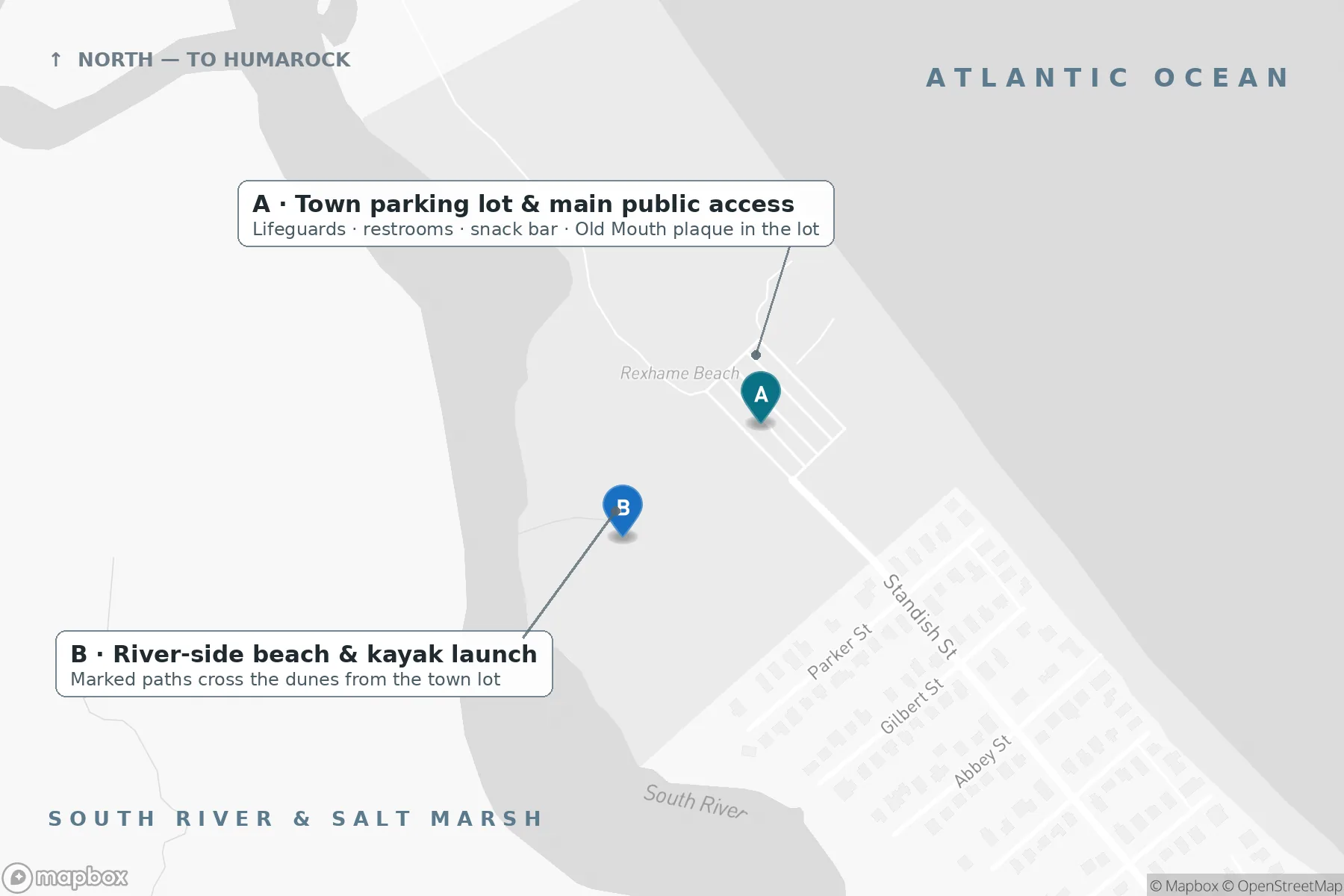
Public access is simple: follow Standish Street to its end, park in the town lot, and walk onto the town beach. The lot is the visitor entrance — it serves both the ocean side and, via marked paths through the dunes, the river side.
Everything around that lot is a residential neighborhood, and the distinction matters. Other paths and dune crossings in Rexhame belong to residents and their guests; they are not public entrances, and there is no second public access point to find. If you arrive by car, the town lot is the way in. Please don't cut through yards or unmarked dunes to reach the sand — the marked paths from the lot get you everywhere the public beach goes, including the river side.
The layout in one picture — one lot, one public entrance, and two very different sides of the same barrier beach:
Parking and fees
Non-resident day passes at the town lot are priced by the day of the week (2026 season):
- $30 Monday–Thursday
- $35 Fridays and Saturdays
- $40 Sundays and holidays
- $10 after 5 PM, every day
Residents park with a town beach sticker, which must be permanently affixed to the vehicle. The after-5 PM rate is the local move: on a summer evening it turns the lot into cheap sunset parking, with the marsh turning gold behind you as the light goes. Fees and rules are set by the town and can change between seasons, so confirm the current details via Town of Marshfield beach parking before you go. While you're in the lot, look for the historic marker for the Old Mouth — more on that below.
Facilities
In season, the town staffs Rexhame with lifeguards and provides restrooms and a snack bar at the beach. There are basketball courts by the lot, and a small fenced-in toddler playground — a genuinely useful detail if you're traveling with a two-year-old who has limited interest in the Atlantic. Planning to cook? The town sells beach cooking permits, which must be purchased 24 hours in advance. Everything on that list is seasonal: outside the summer season, expect the beach itself, the lot, and the paths, but not the staffed facilities. The town's beach page carries the current season's particulars.
Two beaches in one: ocean side and river side
Rexhame is a barrier beach — a low, narrow strip of sand and dune held between the ocean and a marsh system, in this case the South River and its marshes. The strip does real work: it absorbs storms and flooding before they reach the mainland behind the marsh.
The ocean side is the classic New England beach day: open Atlantic, surf, and a long run of sand. The river side is the quieter half. Marked paths cross the dunes from the lot — one runs by the basketball courts — to a sandy beach on the South River, with views across to Humarock. The river side is a popular spot for paddlers and for swimmers who prefer the river, and it's where the sunsets land.
Until 1898, the geography was different: the mouth of the North River opened between Rexhame and the southern end of Humarock, and every boat working the river passed this beach. The Portland Gale of 1898 cut a new mouth and closed the old one. The plaque in the parking lot marks the Old Mouth — a two-minute read that explains the whole landscape in front of you.
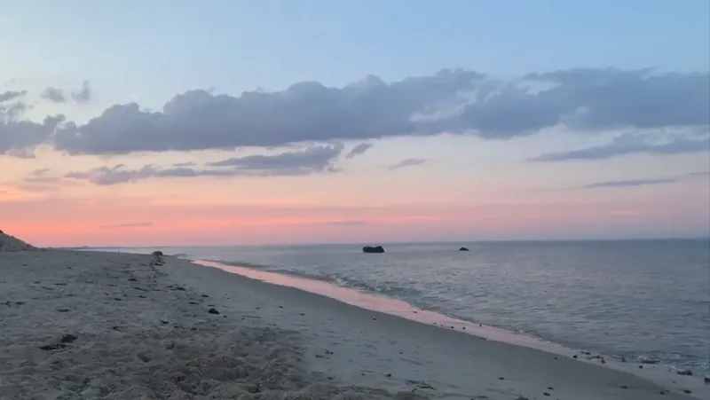
The view north along the Rexhame shoreline, with the dune line running toward Humarock:
Tides run the day
Marshfield's tide is roughly nine feet, twice a day, and Rexhame is two different beaches depending on where the water is. Around high tide the ocean beach narrows to its upper strip, while the river runs deep and full — the easiest window for launching a kayak or paddleboard. Around low tide the ocean side opens into wide flats and sandbars: the best walking of the day, with marsh creeks draining and wading birds feeding in the shallows. On the river, high tide at Rexhame arrives about 45 minutes after Boston's high tide.
Two habits worth adopting: check the tide chart before you set out (the closest NOAA predictions are for Brant Rock / Green Harbor River, station 8446009 — a helpful regional reference, though timing and depth vary along the river), and judge swimming by the day's surf, wind, and conditions rather than by the tide height. When the lifeguards are on duty, swim in the guarded area.
The dunes are doing a job
The dunes are not scenery; they're the beach's structure, and they're fragile. Beach grass holds them together, and the grass is easily killed — the town's beach page notes that even breaking a single blade can kill the plant. Trampled grass means eroding dunes, which means a shrinking beach. Use the marked paths and crossovers, keep off the grass, and respect any seasonal closures around nesting areas. The town runs an ongoing dune restoration project here; staying on the paths is how visitors contribute to it.
Best times to come
- Sunrise: the beach faces the Atlantic — first light over open water, and the flats to yourself.
- Low-tide mornings: the longest walks, across hard wet sand and around the sandbars.
- Late afternoon into evening: swim while the guards are still on, then cross to the river side for sunset over the marsh. After 5 PM, parking drops to $10. Chasing that light with a camera? See our Marshfield photography guide.
- Off-season: no facilities and no lifeguards, but the walking — ocean one way, marsh the other — is there all year.
A Rexhame beach day
Here's a flow that fits the tides instead of fighting them. Arrive on a falling tide and start with the long walk: north along the ocean side while the flats are opening up. Swim late morning in the guarded area as the beach reaches its widest. Lunch from the snack bar, or sandwiches from home — or, if you planned a day ahead, a beach cooking permit and a grill. In the afternoon, cross through the dunes and launch a kayak or paddleboard from the public access on the river side of the lot (bring your own — there's no rental on site) while the river is up. Finish on the river side, watching the sun drop over the marsh.
Easy add-ons within a few minutes: the South River and Rexhame dunes walk for a longer marsh-side ramble; our guide to kayaking the South River for launches, tides, and timing; the Green Harbor Lobster Pound (about a 12-minute drive, seasonal, cash only) for a lobster roll on picnic tables by the Cut River; and Levitate Backyard (about 10 minutes) for tacos and live music after the beach. Choosing between Rexhame and its neighbors? Our comparison of Marshfield's beaches lays out how they differ.
Beadle's Rock and Seaweed Island
Two named landmarks sit in the water off Rexhame's ocean side, and both reward a closer look. Beadle's Rock is the rocky outcrop offshore — the name is an old one on this shore: Joseph Beadle was the first colonial settler in the chain of title for the Rexhame farm, the property that passed through the Kent and Thomas families before becoming the summer lots behind the beach. Anglers know the rocks well: the water around Beadle's Rock is a popular fishing spot, with striped bass a common draw.
Running out from Beadle's Rock and its neighbor, Haystack Rock, is a reef of rocks known locally as Seaweed Island. At lower water the reef shows itself; in calm conditions it is the coast's snorkeling spot — a rocky, weed-draped habitat quite unlike the open sand around it. Treat it with respect: go only in calm conditions, keep an eye on the returning tide, and leave everything you find where it lives. Our hub guide's scuba and snorkeling section covers the underwater side of this coast, including its safety notes.
Rexhame Beach: common questions
How much does it cost to park at Rexhame Beach?
Non-resident day passes are $30 Monday–Thursday, $35 on Fridays and Saturdays, $40 on Sundays and holidays, and $10 after 5 PM. Marshfield residents use a town beach sticker. Confirm current fees via Town of Marshfield beach parking before you go — the town sets them and they can change by season.
Are there lifeguards and restrooms?
Yes, in season: the town provides lifeguards, restrooms, and a snack bar at the beach, plus basketball courts and a small fenced toddler playground by the lot. Outside the summer season, those facilities close.
When is the beach at its best?
It depends what you came for. Low tide gives you the wide flats and the long walks; high tide gives you the deepest river for paddling. For pure atmosphere, come late in the day: swim first, then watch the sunset over the South River marsh — and parking is $10 after 5 PM.
Can I launch a kayak at Rexhame?
Yes. Marked paths from the public lot cross to the South River side of the barrier beach, a popular bring-your-own launch for kayaks and paddleboards. Time it around high tide, when the river is deepest — see our South River kayaking guide.
Can I cook on the beach?
The town sells beach cooking permits, which must be purchased 24 hours in advance. Details are on the town's Rexhame Beach page.
Is Rexhame good for young kids?
It's the most family-ready of Marshfield's town beaches: lifeguards and restrooms in season, a snack bar, and a small fenced-in toddler playground by the parking lot. More family planning help is in our Marshfield with Kids guide.
Where to stay when you visit Rexhame
Rexhame is a cottage village — streets of summer houses behind the dunes — and Driftline’s home, The Egret’s Nest, is one of them: a renovated coastal house here in the village, a 5-minute walk from the sand, with the river and the marsh behind it. Staying here, the beach day starts with a walk instead of a parking lot, and the rest of the coast is a short drive when you want it — Fieldston down the shore, Brant Rock beyond it. The where-to-stay chapter of the main guide puts the Nest in context.
On the Water
Rexhame works on the water as well as on the sand:
- Surfing: the ocean side faces the open Atlantic — see the hub guide's surfing section for this coast's breaks and conditions.
- Surfcasting: fish the ocean side near Beadle's Rock and the river side alike; striped bass are the common draw. The hub's fishing section covers seasons and rules.
- South River fishing: fish the river bends, creek mouths, and current seams from the Rexhame shore — the closest kayak-fishing water to the house, detailed in the fishing section.
- Kayaking & paddleboarding: launch from the river side of the lot (bring your own) — full launches, tides, and timing in our South River kayaking guide.
- Snorkeling: at Seaweed Island, the reef of rocks stemming out from Beadle's Rock and Haystack Rock — see the landmark section above and the hub's scuba and snorkeling section.
Keep exploring
- Best Beaches in Marshfield, MA — a local comparison
- Kayaking the South River
- Marshfield with Kids
- Best Restaurants in Marshfield
- Brant Rock Village Guide
- Fieldston Village Guide
- Green Harbor Village Guide
- Humarock Beach Guide
- Ocean Bluff Village Guide
- Things to Do in Marshfield, MA — the full guide
Sources & further reading
Town of Marshfield beaches page (fees, facilities, and dune-protection rules); the Old Mouth historic marker in the Rexhame lot (the 1898 Portland Gale and the old river mouth); North & South Rivers Watershed Association, South River guides; NOAA tide predictions, Brant Rock / Green Harbor River, station 8446009.
Related Guides
- Best Beaches Near Marshfield — Rexhame, Green Harbor, Duxbury, and more, compared on parking, lifeguards, swimming, and scene — pick the right beach day.
- Kayaking the South River — Public launches, Yup Sup rentals, and how to plan a South River paddle around the tides.
- Marshfield with Kids — Family activities by age, rainy-day backups, free favorites, and a perfect family day.
- Brant Rock Village Guide — Ocean Street's beach, esplanade, and seafood institutions — plus the wireless-station history on Blackman's Point.
Stay near Rexhame Beach
The Egret's Nest, a renovated Marshfield coastal home a 5-minute walk from Rexhame Beach; summer weeks from $2,415.
Last locally reviewed: October 2026.