Kayaking the South River: Launches, Rentals & Tide Planning
The South River is Marshfield's quieter waterfront. The Atlantic gets the postcards, but this tidal salt-marsh river — running between Marshfield and Scituate and reaching the sea at the end of the Rexhame barrier beach — is where locals actually spend unhurried hours: paddling the creeks at high water, watching the marsh drain at low tide, and timing the whole day around the water. The house pattern here sums it up: river in the morning, ocean in the afternoon. This page covers the river's character, the public places to launch, the rental option, and how to plan a paddle around a nine-foot tide. This is the river chapter of our Marshfield Local's Guide, where the beaches, restaurants, and events that fill the rest of the week live.
The river itself
The South River is a working tidal river, not a lake with a current. Twice a day the tide fills it; twice a day it empties back out through the marsh. At high water the river is wide and deep, with the launches easy and the creeks open all the way into the marsh grass. As the tide falls, the creeks narrow and drain, mudflats appear, and wading birds move in to feed along the edges. The scenery is low and green rather than dramatic — cordgrass marsh, winding creek mouths, current seams where the water hurries — and it changes completely between visits depending on where the tide is when you launch.
The river also divides its moods by geography. Down toward the mouth, past the Rexhame dunes, the water is bigger and the current runs harder, and it feels close to the open Atlantic it is about to join. Up at the head of the navigable river, the marsh closes in and the paddling gets quieter and more intimate. Most first outings are better spent in the middle and upper stretches; the mouth rewards experience and the right tide.
It has been working water for as long as the town has stood. Marshfield's first grist mill was founded on the South River in 1654 by William Ford and Josiah Winslow, and in the early 1800s the Duxbury & South River Manufacturing Company ran cotton and woolen mills at Chandler Pond and at what is now Veterans Memorial Park. The mills are gone; the river that ground the town's grain and powered its first industry is the same tidal water you are paddling — settlement followed this river, and it still sets the day's schedule. The watershed association tells the fuller story in its history of milling and manufacturing in the river valley.
Public launches
There are three public launch points worth knowing, plus a fourth put-in: Marshfield Town Landing on Ferry Street, which the guide's fishing notes use as the lower-river access. All of them are bring-your-own-boat spots except where a rental dock is involved, covered below.
Rexhame Beach launch
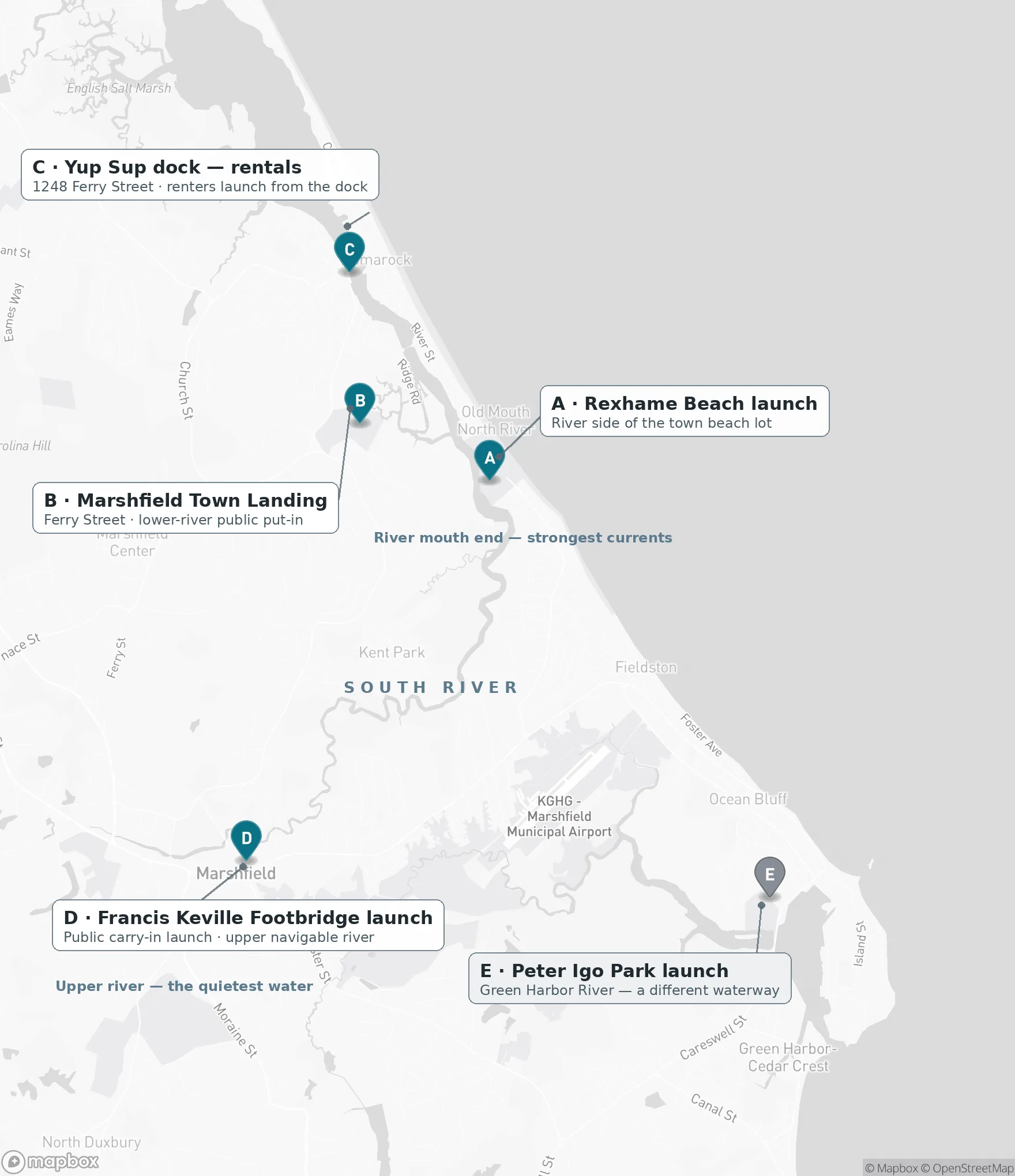
The closest launch to the house — about two minutes by car, at the Rexhame end of the river. Put in on the west side of the Rexhame Beach parking area: walking paths lead from the public beach area across to the South River side of the barrier beach, where you can launch into the marsh. Bring your own kayak or paddleboard. Because this shares the beach lot, the beach's parking rules apply in season: non-resident parking is $30 Monday–Thursday, $35 on Fridays and Saturdays, and $40 on Sundays and holidays, dropping to $10 after 5 PM, and the beach itself has lifeguards, restrooms, and a snack bar in season. Stay on the marked public paths through the dunes, and observe any seasonal dune or nesting-area closures.
From the house it's a five-minute walk to the beach itself — this is the paddle you can do almost on impulse when the tide and the morning line up.
Francis Keville Footbridge launch
The upper-river option, behind 1880 Ocean Street and about an eight-minute drive. This is a public carry-in launch — you'll walk your canoe, kayak, or paddleboard down a short approach path — that puts you on the upper navigable South River. The reward for the short carry is the quietest water on the river: a sheltered salt-marsh stretch where the current is gentler and the marsh does the talking. If you want one launch that shows you what the river is like away from the mouth, this is it.
Peter Igo Park launch
A different waterway, worth knowing about: Peter Igo Park (29 Marshall Ave, near Brant Rock, about a 12-minute drive) has a public dock and launch onto the Green Harbor River, near the Daniel Webster Wildlife Sanctuary. The water there is sheltered with a light current, which makes it one of the easiest local options for a relaxed paddle — a good first outing, or the choice when the South River's tide window doesn't suit your day. Bring your own kayak or canoe.
All of the launch points on one map — with one caution the map can't show: the points are not equally suitable under all tide conditions. The launches are easiest around high tide, shallow reaches thin out as the tide drops, and currents strengthen toward the river mouth. Plan from the tide and safety sections below; this map is the geography, not the go-ahead.
Rentals — and a motorized alternative
Yup Sup is the rental answer on the South River. From their dock at 1248 Ferry Street (about a 10-minute drive), they rent single and tandem kayaks and stand-up paddleboards, and you launch directly from the dock into the river — no car-topping, no hunting for the put-in. Rentals run May through October. Reserve online or by text ahead of time, especially on summer weekends, and ask the dock team about the best tide window for your outing; they'll steer you to the right hours. Their sunrise and sunset tours are the memorable version of this paddle, and those require advance reservations.
If your crew would rather ride than paddle, Roht Marine rents pontoon boats on the neighboring North River from 2205 Main Street (about a 15-minute drive). Rentals are arranged by phone and go first-come, first-served, so reserve as early as you can; a 50% deposit holds the boat. A half day runs four hours at $400, a full day eight hours at $750. It's the easiest way to put a whole group on the water for an afternoon, swimmers and non-paddlers included.
How the tide shapes your paddle
Marshfield runs on a roughly nine-foot tide, twice a day — two high tides and two low tides, every day. On a river this tidal, the chart is not background information; it is the plan. The South River is easiest around high tide, when the water is deepest, the launches are simplest, and the creeks are fully open. Currents strengthen toward the river mouth, and shallow reaches get thin as the tide drops.
The classic outing shape follows from that: head out as the tide is coming in and let the flood carry you upriver, turn near the top of the tide, and ride the ebb back down toward your launch. Done well, the water helps you in both directions and you're never grinding against a full-strength current at the end of a long paddle. Shorter outings can simply bracket high tide — launch an hour or so before it, be back an hour or so after.
For predictions, use NOAA's Brant Rock station (8446009), the closest NOAA station to Marshfield, as a helpful regional reference. It is a reference, not a promise: tidal timing, currents, and water depth vary by launch location along the river and with the weather, so confirm conditions with your rental operator before you paddle. Our main guide's Tides section walks through how the same tide cycle shapes beach days and fishing as well.
Safety, plainly
A tide chart tells you where the water will be, not whether you should be on it. High tide alone does not guarantee safe or easy conditions. Before any launch, check three things together: the tide, the wind, and the weather. Wind can chop up open stretches and push a paddleboard around; conditions near the river mouth are the least forgiving on the river; and a forecast that changes mid-afternoon can turn a pleasant return leg into work. Judge all of it against your own experience, and if you're renting, follow the outfitter's guidance on timing — they read this river daily.
The standing habits are simple. Wear a life jacket. Tell someone where you're launching, where you're headed, and when you expect to be back — a float plan, even an informal text, is what turns a problem into a rescue. Pick your turnaround point before you launch and honor it, so the tide brings you home instead of stranding you against it. And start conservative: the sheltered water at the Keville Footbridge or on the Green Harbor River is a better classroom than the mouth. The marsh will still be there when you're ready for it.
When to go
The rental season runs May through October, and the local rhythm puts the river first: mornings for the marsh, afternoons for the ocean. Early starts also tend to mean the river at its calmest and the launches at their emptiest. For the version of this paddle people talk about afterward, book one of Yup Sup's sunrise or sunset tours — the marsh at first or last light, with the tide doing the work. And when the tide is out instead, swap the paddle for the low-water version of the same landscape: a walk on the wide Rexhame flats while the creeks drain and the birds feed.
Keep exploring
- Rexhame Beach Guide — parking, access, and beach-day planning at the river's mouth.
- Best Things to Do for Couples — tandem paddles, marsh sunsets, and date-night plans.
- Explore a beach vacation before the bridges — Marshfield as a Cape Cod alternative: beaches, seafood, and two tidal rivers, with no canal crossing to reach them.
- Best Beaches Near Marshfield — how Rexhame compares with Green Harbor, Fieldston, and Humarock.
- Marshfield with Kids — family days, including tandem paddles and the rainy-day backups.
- Things to Do in Marshfield, MA — the full local guide, with the complete Tides section and every launch and rental in context.
Related Guides
- Rexhame Beach Guide — Parking, public access, lifeguards, tides, and the best times to go — the complete visitor guide to Marshfield's home beach.
- Best Things to Do for Couples — South River sunsets, date-night dinners, tandem paddles, live music, and slow mornings — Marshfield, planned for two.
- Best Beaches Near Marshfield — Rexhame, Green Harbor, Duxbury, and more, compared on parking, lifeguards, swimming, and scene — pick the right beach day.
- Green Harbor Village Guide — Marshfield's working harbor: the lobster pound, the dike, the town pier, and a broad resident beach.
Stay in the Rexhame area
The Egret's Nest — a renovated Marshfield coastal home a 5-minute walk from Rexhame Beach; summer weeks from $2,415. Launch a kayak in the morning, walk to the ocean in the afternoon. Check availability →
Last locally reviewed: October 2026.